


Plant Canopy Analyzer
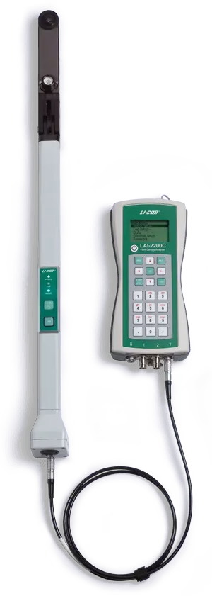
LAI-2200C Plant Canopy Analyzer
- Great Measurements without Disturbing the Canopy
- Computes LAI even in row crops and isolated trees that other methods cannot measure.
- Accurate in most daylight conditions, unlike other methods which require specific sun angles or cloud cover.
- Designed by both scientists and engineers to provide quick and accurate results, as well as advanced processing options.
- Measures five zenith angles in a single measurement.
- Used in a wide range of applications, including studies of canopy growth, canopy productivity, forest vigor, canopy fuel load, air pollution deposition modeling, insect defoliation studies and remote sensing.
Please Contact for Price
- Satisfaction Guaranteed
- Superior Quality
- Custom Solutions
- Comprehensive Support
- Secure Payment Options
Description
LAI-2200C Plant Canopy Analyzer: World standard for indirect LAI measurements.
Great Measurements without Disturbing the Canopy
The LAI‑2200C Plant Canopy Analyzer uses a non-destructive method to easily and accurately measure Leaf Area Index (LAI). It consistently outperforms other methods such as Ceptometry and Hemispherical Photography in terms of flexibility, advanced features, accuracy, and ease of use.
Special Features
- Canopy Variety: Computes LAI even in row crops and isolated trees that other methods cannot measure.
- Any Sky: Accurate in most daylight conditions, unlike other methods which require specific sun angles or cloud cover.
- Proven Results: Designed by both scientists and engineers to provide quick and accurate results, as well as advanced processing options.
- True Gap Fraction: Measures five zenith angles in a single measurement.
Applications
Get Measurements from Your Environment of Study
The technology of the LAI‑2200C Plant Canopy Analyzer is used in a wide range of applications, including studies of canopy growth, canopy productivity, forest vigor, canopy fuel load, air pollution deposition modeling, insect defoliation studies and remote sensing.
LAI is also one of the fundamental measurements associated with carbon flux studies and global carbon cycle research. The technology of the LAI‑2200C and its predecessor, the LAI‑2000, is the most commonly used indirect LAI measurement technology worldwide.
Instrument
Optical Sensor
Five silicon detectors arranged in concentric rings
Saves time — no need to wait for the sun’s position to change. Measures light from five different zenith angles with one reading.
Filter reduces errors from transmitted and reflected light
Sensor receives radiation below 490 nm only, where leaf reflectance and transmittance are minimal.
Correction for light scattering
A diffuser cap is used for collecting ancillary data for applying scattering corrections when operating in direct sunlight.
Automatic logging and autonomous modes
Useful for measuring tall canopies using two sensors.
Measures LAI of understory plants
Any object that blocks the sensor’s field-of-view by the same amount for both above and below-canopy readings will not influence the results. This allows, for example, measuring the LAI of grass beneath a tree as long as the tree is equally present in both above and below-canopy readings.
View restricting caps
Allow LAI measurements of small plots and hedges by blocking undesired objects from the sensor’s view, such as the operator or a neighboring plot.
Console
Menu-driven interface
View GPS coordinates, Leaf Area Index (LAI), standard error LAI, apparent clumping factor, mean tilt angle (MTA), standard error MTA, sample size, and more. Basic data processing is available directly on the console.
Integrated GPS
Add location information with each reading or log GPS data independently with GPS tagging.
Light sensor logging
Use the two BNC connectors for attaching LI-COR quantum, pyranometer, or photometric sensors.
User-friendly features
Take advantage of automatic logging, USB data transfer, and a memory capacity of 1.5 million readings.
GPS Integration
For light scattering corrections
The GPS module generates the latitude, longitude, and UTC data used to determine solar position for light scattering corrections when operating under direct sunlight.
For mapping Leaf Area Index
Each above or below-canopy reading can be paired with GPS data for that location. In addition, “tagging” logs GPS data for your location whenever a numbered key is pressed (1–9) while GPS is enabled. Using files containing GPS data, the FV2200 PC application generates KML files for viewing on Google Earth. Parameter choices include:
- Average LAI (illustrated by column height)
- LAI Profile (3-D illustration along a path)
- Polygons (delineating a study site)
- Path for “above” or “below” readings


Reviews
There are no reviews yet.